Bushfire Threat to Nillumbik Shire

Pine plantation fire adjacent to Hume Highway at Wandong Victoria.
David Packham
Rural Fire Consultant
11 July 2003
Introduction
At the request of Mary McDonald on behalf of the Nillumbik Shire Rate Payers Association I undertook a one day inspection of the Nillumbik Shire and some surrounding areas to gain a qualitative assessment of the risk of bushfires and to comment upon the possible impact of the C12 overlay.
Observations
There has not been as an intense history of fires in Nillumbik as in some adjacent areas (e.g. Yarra Ranges). I cannot suggest any reason for the apparent lack of fires. It must not be taken, as immunity for Mt Macedon had not been burnt for a hundred years before it was destroyed in 1983. The possibility of complacency is real. And a social survey could well be instigated to assess the bushfire threat awareness of the residents.
My inspection commenced near the Hume Freeway, to the west and north of the Shire. The fire in photo 1 Is a fire started adjacent to the Hume Freeway that would have the potential to reach the Shire either directly or by spotting. On this occasion a SW wind change stopped the southwards spread. Nevertheless fires from the Hume not quite as dramatic as in photo 1 are a regular event and with a good run could enter Nillumbik on a wide front.
The inspection continued to included the Yan Yean Catchment and the Kinglake National Park. The Kinglake – Heidelberg Rd then took me through the villages of St Andrews, Cottles Bridge and the towns of Hurstbridge and Wattle Glen. The Plenty Gorge and finally out of the Shire by the South East through the rural residential and urban interface that surrounds the Sugar Loaf Reservoir. The inspection was clearly only a sample, almost a transect but was sufficient for me to feel confidence in my qualitative observations.
I intended to take fuel samples but the obvious lack of much previous fire and fuel reduction meant that the fuels could be expected to be at their maximum equilibrium level. A rigorous fuel sampling would be difficult due to the wide range of ecosystems in the Shire. Over a long period of time if a real fire protection strategy was to be implemented fuel surveys would however be most helpful.
A more comprehensive risk analysis and one that might be expected in a Shire with such a high risk would involve a study of the climatology, fuel sampling, topography and fire history as well as identification of the major hazards and risks. Such an analysis will be essential for successful fire preventation preparation but for now the fire risk is so dramatic that any further detail would not change the major conclusions.
The Strategic Threat
Most damaging fires in Victoria are driven at considerable speed (max reported 27 kph for grass and 12kph for forest fires) by hot dry North – Northwest winds and then consume large areas at the passage of a SW wind change. Often the wind moves to the west before going back to the Northwest as a pre-frontal trough passes and then often violently to the Southwest with the cold front. It should be noted that 46 of the 47 people who died in the 1983 fires died on the passage of the front or soon after. Occasionally dangerous fires have travelled from the N-NE even SE but due to their generally more humid air and lower velocities those winds are not considered to be a very great threat.
The major fuel areas are to the North and North west of the Shire are in the Yan Yean Catchment and the Kinglake National Park and outside the Shire in the State Forests to the North.
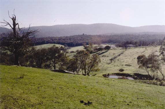
Photo 2. State Forest to the North of Nillumbik Shire. Map reference UTM 55H 0328676 5852235 Direction of photograph 040 magnetic.
Yan Yean has not yet experienced fire for many decades and the fuel loads are very dangerous and will be a source of ignitions by spot fires into the Shire. Further spotting potential can be identified from the Mt Disapointment State Forest and the Kinglake National Park
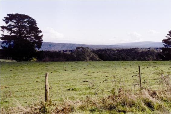
Photo 3. Taken from the Frank Thompson Reserve to the northwest showing considerable forest fuels upwind of the Nillumbik Shire. Mt Macedon is shown faintly in the far distance. 55H 0351484 5845891 Direction 290 mag.
The large areas of fuel to the north and west creates a serious threat to the whole shire and ultimately to the urban edge developments in the southern parts of the Shire(Photo 2). The other targets for rampant fire spread are the rural residents throughout the Shire and in the Central and Eastern sections the linear villages along the Heidelberg-Kinglake road and the Kangaroo-St Andrews Road. Like Canberra the built up areas are downwind from the major accumulations of heavy fuels.
Valuable and important ecosystems in reserves and roadsides and private property are also at threat as are the environmental and water values in the National Park catchments.
The fuels consist of wet and dry forests, grasslands and some low quality eucalypt forests with grassy understorey and a deceptive fuel load.
There are large quantities of aerofoil shaped candle bark from ash trees that are associated with long distance spot fires (Photo 3). Spot distances of 33 kms have been recorded from this type of fuel and I have observed ignitions by spot fires from an Mt Dandenong fire in Upper Beaconsfield at some 12 kms. The candle barks fuels in abundance threaten the whole of the Shire.

Photo 4. Maximum fuel levels exist in water catchments because of lack of fuel management 55H 0334451 5841454.
To the west and north of the Shire lies the Mt Disappointment State Forest with considerable fine fuel concentrations and an active fire history.
To the west also lies the lesser but variable risks associated with grasslands that surround the Hume Highway. In 1969 a fire to the west of the Hume had no trouble in travelling 40km to the east and overrunning Yea, all in one afternoon. Such distances of fire travel are not at all unusual.
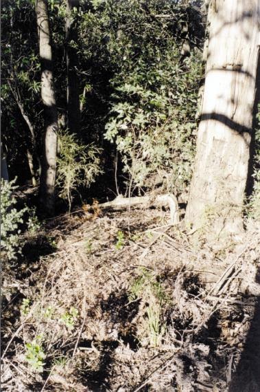
Photo 5. 100m from major power lines showing fuels that have not been burnt for 30 – 50 years. 55H 0350396 5846050
Especially noticeable is the large clusters of candle bark and fibrous bark (photo 5) on the road edges
There are private lands and public lands within the shire that have no apparent attempts at fuel management.
Initial attack on fire ignitions can be very effective in controlling potentially disastrous fires. It would be necessary on days of 40 degrees and 40 kph winds to ensure detection and suppression in the first 5 – 10 minutes. I doubt that much of the Shire can be protected by relying upon initial attack.
My intention was to take fuel samples but once the lack of recent fires or fuel management was apparent it seemed pointless. Over most of the area the fuels would have been at their maximum equilibrium level. For strategic analysis purposes it would be safe to assume that the forest fine fuel levels would be between 25 and 30 tonnes per hectare. That is at least 4 – 5 times the maximum safe fuel level and an average of 3 – 4 tonnes per hectare are needed to render an area “fire resistant”.
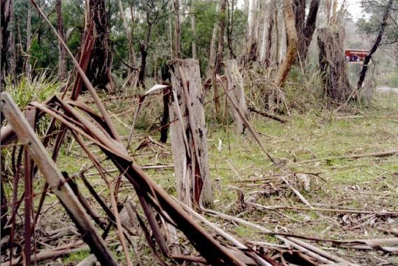
Photo 6. Candle bark fuels capable of very long range spotting along a major intersecting road and “fire break”. 55H 344175 5835 703.
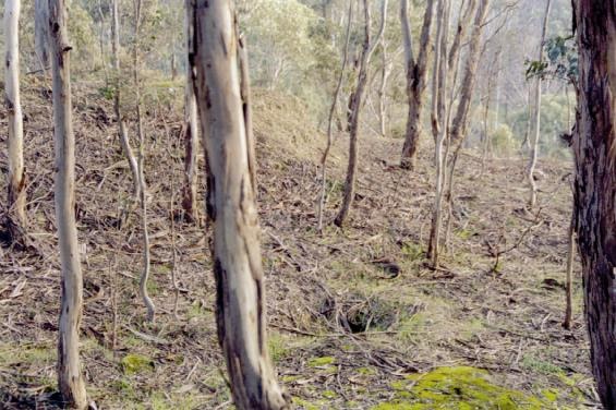
Photo 7. Showing low grassland fuel but considerable bark fuels. An interesting combination at the Plenty Gorge apparently not burnt since 1957.
The strategic threat – summary.
The threat is extreme and in my opinion ranks with (but less than) the threat to Hobart before the 1967 fires and at about the same level as Canberra this year. There are large areas of publicly owned land without any apparent fuel reduction up wind of many villages and towns and the heavy developments in the south of the shire and in adjacent shires.
The mix of fuel, unsafe roadsides and embedded houses will all ensure that when a large fire impinges upon the area a major disaster will result.
Nillumbik is truly living on “borrowed time”.
House loss in High Intensity Bushfires.
Wilson (1984) undertook a study of house loss in the 1983 fires at Macedon. A complex statistical analysis determined the major factors and enabled the probability of house survival to be calculated. The method used is objective and gives guidance to improvements so that a homeowner can achieve a chosen degree of safety.
The most important factor in the survival of a building is the intensity of the fire around the building (within 30 – 40m). The fire intensity is determined by the fuel concentration and slope for given weather conditions and fuel dryness. Photo 9 is a house on the northern boundary of the shire with a probability of survival close to zero. There are many such houses in the shire and if permitted by the disputed overlay there would be many more. Another house at the other extreme (photo 8) would have close to 100% survival if occupied during the passage of the fire. However it is not necessary to undertake such drastic landscaping to achieve a high degree of protection. What needs to achieved is the option of achieving something in between these two extremes but close to 90 – 95% probability of survival

Photo 8. A house close to 100% survivable. It is not however necessary to go to such lengths to achieve survivability above 90% if the design is suitable and if the surrounding ground fuels are controlled.
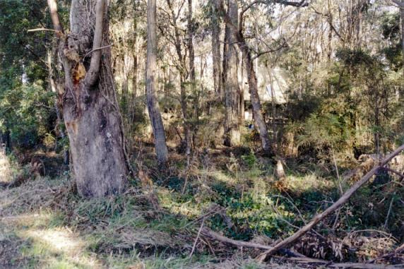
Photo 9. House just outside the northern boundary of the Shire with high levels of contiguous fuel. The probability of survival would be very low. 55H 035333 584407
Photo 10. Plenty Gorge Park. A valuable and attractive reserve that contains a range of fuel types and fuel levels. There are housing developments at the edges.
If fuels are kept low then an environmentally attractive house can established which would achieve greater than 95% probability of survival.
For strategic purposes the observation can be made that for unprepared communities some 50% of the houses survive a high intensity bushfire. If fuel removal is prevented and trees close to the house enforced it can be shown that house survival will probably drop from 50% to 17%, i.e. the application of such rules would result in an increase house loss of 33%.
The excessive fuel in the Shire especially the “spotting” fuel not only threatens the Shire of Nillumbik but also areas to the south east and to a lesser extent in the northeast. Thus the neglected fuels of Nillumbik threatens the residents of the Yarra Ranges including the Dandenongs.

Photo 11. The problem with very close and overhanging trees. The absence of guttering would help. 55H 0340385 5832405.
Conclusions
The Shire of Nillumbik is living on borrowed time. If the current drought ends the threat for now will end. That would then give the Shire time to improve its fire protection to an acceptable level.
A prohibition on fine fuel removal and the requirement for vegetation close to houses is a recipe for increased house destruction.
The major thereat comes from the high fuel levels in the public ally owned lands to the north. Some of the neglect comes from a lack of resources but some comes from a determination to not manage dangerous fuel levels.
Less but still serious threats come from Shire reserves and roadsides that increase the danger to residents and emergency services to extreme levels.
Recommendations
- Scrap as soon as possible any planning process that puts residents into jeopardy. Roadsides where accumulation of ground fuek poses a serious threat and are in conflict with the Shire’s network of major and minor firebreaks.
- Scrap amendment C12 requirements that threaten life and property.
- Undertake a fine fuel and slope survey of the shire to help to estimate quantitatively the threat to residents in Nillumbik.
- Take action to either scrap the concept of linear firebreaks or make them safe.
- Undertake a probability of survival analysis of random samples of housing in the Shire as a database to estimate the possible outcome of a major fire event.
- The Shire to fund an independent survey of attitudes of residents to the bushfire threat and their prepaaredness. There is a previous survey for Warrandyte by Berringer (Monash University) about 10 years ago.
- Using the data from recommendations 2 – 5 develop a stategy that will give a reasonable degree of safety to the residents.
Reference
Wilson, A.A.G. (1984), Assessing the Bushfire Hazard of Houses: A Quantative Approach. Technical Paper No.6, Rural Fire Reasearch Centre.
CURRICULUM VITAE
DAVID PACKHAM
NAME David Roy Packham
QUALIFICATIONS
Diploma of Applied Chemistry (Royal Melbourne Institute of Technology, 1964.) Master of Applied Science (Victorian Institute of Colleges, 1973.) Foundation course in Human Reasource Management (Institute of Personnel Management Australia, 1991.)
AWARDS
Order of Australia Medal, 1991, For service to the development of arial ignition techniques for bushfire management.
Fire Protection Association Australia 2002, The A.V. Viscogliosi Award for Excellent for Outstanding Service to Fire Protection.
MAJOR ACHIEVMENTS
Co-developer of arial prescribed burning that has been adopted as a major fire control technique throughout Australia and North America.
Co-inventor of the VESDA high sensitivity building smoke detection system that is the most advanced building fire detection system and applied throughout the world.
Initiator of a 30 person year study of smoke from biomass burning that has been used as input data to greenhouse climate models.
Public advocate for the non-evacuation as a strategy to decrease life and property loss dring disastrous bushfires.
Consultant to Australian International Development Assistance Bureau as technical leader of the Joint ASEAN / Australia pre-feasibility study on Transboundary Pollution of Haze in ASEAN countries, September 1992.
EMPLOYMENT ACTIVITIES
Retired from the Australian Public Service however I maintain an active constancy program and other work associated with rural fires.
Consulted to WorkCover Victoria, the Victoria Police and the Victorian Coroner on the Linton fire incident.
Have completed the first stage on a joint technical assistance study in Indonesia with Fortech, Jaakko Poyry, the Asia Development bank and national Development Planning Agency of Indonesia (BAPPENAS) to develop an investment strategy to migrate drought, fire and haze in Indonesia.
Provide advise on burning strategy and tactics for prescribed burning on the Mornington Penninsula with Dr Ron Gross.
Supervised two Honors students and one Masters student in rural fire studies.
Briefly a Research fellow in the Monash Department of Mathematics working with Dr Terry Clark from the National Center for Atmospheric Research, Boulder Colorado on a coupled fire/atmosphere meso-model for fire spread.
Recently a Senior Professional Officer in the Australian Bureau of Meterology as the Supervisor Rural Fire Weather Warning Services. The position involved policy development and research. I had the national responsibility for all the Bureau’s fire weather warning services.
Recent major research project in the develpment of an objective method of forecasting fire danger. This project was conducted by a PH.D. student in the Department of Goegraphy and Environmental sciences, Monash University. Other current research is investigating the link between global cooling and biomass burning and coupled fire and meso-meteorological models.
PREVIOUS POSITIONS
Previous position was as Deputy Director of the Australian Counter Disaster College (Department of Defence). I was responsible for the professional aspects of the College’s activities, which included courses, workshops and seminars on disaster management for about 1200 participants each year. The college had a small research programme and a total staff of 49. That appointment lasted from 1985 to 1987.
For five years from 1980 to 1985 I was a part time lecturer in inorganic chemistry and director of the National Center for Rural Fire Reasearch at the Chisholm Institute of Technology (now Monash University).
Between 1962 and 1980 I worked in bushfire research in CSIRO in the Division of Physical Chemistry which has had many name changes including Division of Applied Chemistry and the Division of Chemical Technology. I started in 1962 as a Technical Assistant and was a Principal Research Scientist when I resigned in 1981. My reasearch at CSIRO was centered on heat and mass transfer in bushfires, aerial prescribed burning, smoke chemistry and dispersion, nephelometry, air pollution, fire detection in buildings and remote sensing of bushfires. I maintained an instrument rating for multi-engined aircraft and specialized in the use of aircraft for atmospheric measurement.
OTHER INTERESTS
Environmental conservation, keelboat sailing, bicycle riding, motor sport, flying, landscape photography, wine making and life.
RECENT ACTIVITIES
Called in as a consultant to the Country Fire Authority for a review of the January 21 fire in the Dandenongs and Mornington Penninsula.
Consulting to Forestmount for the burning of 80 hectares of windrows contiguous to housing estates in Mt Martha.
Facilitator to the Country Fire Authority, CSIRO and the Bureau of Meteorology on developing a nation strategy for satellite measurement of grassland curing as a measure of fire risk.
Guest presenter at a Bureau of Meteorology one week workshop in Hobart on fire behaviour models for fire weather forecasters.
Presented the opening address to the Annual Meeting of the Victorian Rural Fire Brigades Association.
PUBLICATIONS
King A.R. & Packham D.R., (1964) Miscellaneous Experiments Relevant to Bulk Sugar Fires. CSIRO Div. Phys. Chem. Report No 10, 20pp.
Packham, D.R. (1965) Heat Transfer in Bushfires, Bushfire Bulletin, 13-15.
King A.R. & Packham D.R., (1965) An Evaporation Retardant to Improve Water used in Rural Fire-fighting. Aust. For 29 (2), 80-88.
Baxter J.R., Packham D.R. & Peet G.R. (1966) Control Burning from Aircraft. CSIRO Chemical Res. Lab. Melbourne. 26pp.
Packham D.R. (1966) Mapping Forest Fires through Smoke Aust, For. 30, 268-73.
Taylor R.J. & Packham D.R. et al (1968) A Meso-meteorological Investigation of Five Forrest Fires. CSIRO Div. Met. Phys. Tech. Paper 18. 19pp.
Cheney, N.P., Hooper R., MacArthur, D.A., Packham, D.R., and Vines, R.G. Techniques for the Aerial Mapping of Wild Fires. Australian Forestry Research 3(4): 3-20.
Packham D.R. & Peet G.R. (1970) Developments in controlled burning from aircraft. CSIRO Chemical Res. Lab. Melbourne. 18pp.
Packham D.R. (1971)Heat transfer above small Ground fires.Aust. For. Res. 5 (1) 19-21.
Packham D.R. (1971) Fire Control and Aircraft in the Northern Territory. Proceedings of the 1971 Tropical and Arid Fire Symposium, Darwin.
Packham D.R. & Pompe A. (1971) Radiation Temperatures of Forrest Fires. Aust. For. Res 5(3) 1-8
Packham D.R. & MacArthur D.A. (1971) Radiation from an ethylene diffusion flame. Combustion Sci. and Tech. 2. 299-306.
Taylor R.J., Packham D.R., et al. (1971) Some meteorological aspects of three intense forest fires CSIRO Div. Met. Phys. Tech. Paper 21. 21pp.
Vines R.G., Packham D.R., et al. (1971) On the nature, properties and behaviour of bushfire smoke. CSIRO div. Appl. Chem. Tech. Paper 1. p.
Bermingham, A., Packham D.R., and Vines, R.G. (1971) The Age of the Petrified Forest near Denmark, Western Australia. Search 2: 11-12.
King N.K., MacArthur D.A., Packham D.R. Taylor R.J. & Vines R.G. (1972) Studies on bushfire smoke. Symp. Fire in the environment, Denver, USA.
Taylor R.J., Packham D.R., et al. (1973) Convective Activity above a Large-scale Bushfire. J Appl. Meteorology, 12, 1144-50.
Evans L.F., King N.K., Packham D.R. & Stephens E.T. (1974) Ozone measurements in smoke from forest fires. Env. Sci. and Tec. 8, 75-76.
Packham D.R., Eccleston A.J. & King N.K. (1974) The scattering coefficient and mass concerntration of smoke from some Australian forest fires. JAPCA 24, 1047-50
Packham D.R., Gibson L & Linton M. (1974). The detection of smoke in air-conditioned and ventilated buildings. Control (Aust.) 1, 777-85, also Telecom Journal of Aust. 26, 261-67. and Fire Int. 48, 50-59.
Evans, L.F. King, N.K., MacArthur, D.A. Packham, D.R. and Stephens, E.T., Further studies of The Nature of Bushfire Smoke. Division of Applied Organic Chemistry Technical Paper No. 2, Commonwealth Scientific and Industrial Research Organization, Australia.
Packham D.R. Hamilton J.A., Gibson I. & Weeks C. (1976) Ambient smoke levels at the Honeysuckle Creek Space tracking Station and the selection of fire alarm levels. Control(Aust) 3, 87.
Evans L.F., Weeks I.A., Packham D.R. & Eccleston A.J. (1977) Photochemical ozone in smoke from prescribed burning forests. Environmental Sci. & Tech. 11: 896
Vines R.G. & Packham D.R. (1978) Properties of bushfire smoke: the reduction of visibility resulting from prescribed fires in forests. JAPCA 28: 790.
Vines R.G. King N.K. & Packham D.R. (1977) The loss of selenium and other elements from burning forest litter. Aust. For. Res. 7: 265-8.
Vines R.G. & Packham D.R. (1978) Air pollution from forest fires. Aust. Environment Council Symp. on Air Pollution Diffusion Modelling, Canberra. Aust.
Packham D.R. (1977) Physics and bushfire protection. Victoria’s Resources 19(5).
Packham D.R., Donaldson B & Clarke L.N. (1980) Selection of Fire alarm levels for the in-duct detection in a hospital. Control (Aust.) 6. 117.
Ross D.G., Knight I., Packham D.R. & Vines R.G. (1902). Mathematical smoke dispersion model: prescribed burns. CAMM Report No. 1, Chisholm Inst. of Technology, Vic. 52pp.
Ross D.G., Packham D.R. (1981) On modelling visibility reduction: prescribed forest burns. 74th Annual Meeting, APCA Philadelphia, USA.
Tassios S. & Packham D.R. (1984) An investigation of some thermal properties of four fabrics suitable for use in rural firefighting. National Centre for Rural Fire Research, Tech. Paper No. 1 Chisholm Inst. of Technology, Vic., Aust.
Packham D.R., (1984) Planning for a Hot Time. Australian Insurance Journal, Feb 29-32.
Packham D.R. and Packham, H.F. (1984) Bushfires and Mudbrick houses, Grass Roots ():14.
McMahon A., Packham D.R., Vines R.G. & Silberbauer G. (1984) Four Views on the Bush-fire Problem in Rural Victoria, Australia. National centre for Rural Fire Research, Tech. Paper No. 2, Chisholm Inst. of Technology, Vic., Aust.
Tassios S & Packham D.R. (1985) The release of methyl chloride from biomass burning in Australia. JAPCA 35, 41.
Packham D.R. Sirakoff C., McKelvie I., Gabric A., Middleton J., Nevett G.C., Raisin G., Tassios S. and Wilson A.A.G. (1985) Project Aquarius – The prediction of extinguishment of forest fires by arial attack, part I: Operation of the ASM1/84 Computer Model. National Centre for Rural Fire Research, Tech. Paper No. 4, Chisholm Inst of Technology, Vic., Aust.
Packham D.R. Sirakoff C., McKelvie I., Gabric A., Middleton J., Nevett G.C., Raisin G., Tassios S. and Wilson A.A.G. (1985) Project Aquarius – The prediction of extinguishment of forest fires by arial attack, part II: Operation of the ASM1/84 Computer Model. National Centre for Rural Fire Research, Tech. Paper No. 5, Chisholm Inst of Technology, Vic., Aust.
Aust. Patent 9230/72 “Smoke Detector”
Swiss Patent 8221/73 “Smoke Detector”
U.K. Patent 25660/73 “Smoke Detector”
Packham D.R., & Pierrehumbert, C. (1990) “Bushfires in Australia: A Problem of the Weather” Bulliten of the World Meteorological Organisation 39: 21,
Packham D.R. “Bushfires in Australia: What is the Risk?” Australian Planner 30:8, 1992.
Noar, P., Packham D., and Drosdowsky, L., “The Role of Meteorolgy in Natural Disater Reduction”, AODRO Newsletter 8:3, 1990.
Krusel, N. Packham D.R. and Tapper, N. “Wildfire Activity in the Mallee Shrubland of Victoria, Australia.” International Journal of Wildland Fire 3(4):217-228, 1993.
Packham D.R., Bally, J. Clark, T., Knight, I., Krusel, N., and Tapper, N., “The Orchestra Grows! Two new fire Models.” Conference of Landscape Fires ’93. Perth, Sept 1993.
Krusel N., Packham D. and Tapper, N. Wildfire Activity in Two Vegetation Types in Victoria, Australia. 12th Conference on Forest and Fire Meteorology – Fire, Meteorology and the Landscape. Oct 26-28 Jekyll Island, Georgia.
Bally, J., Elliot, J., Jones, R., Kirby, B., Packham D.R. Salter, J. and Silberbauer, G. “Guidelines for Effective Warning” Australian Emergency Management Institute, Mt Macedon, Victoria, 4pp. 1993.
Salter, J., Bally, J., Elliot, J., and Packham D., “Vulnerbility and Warnings” IDNR Conference Natural Disasters – Protecting Vulnerable Communities. 13-15. London 1993.
Beringer, J., Packham D.R. and Tapper, N.J. “Areal Extent of Dry Season Biomass Burning in Northern Australia, and Resulting Atmospheric Emissions” 12th Conference on Fire and Forest Meteorology, Oct 26-28 Jekyll Island, Georgia. 1993.
Packham D.R., (1995) Evacuation in Wildfires, The Australian Experience, Wildfire, June 1995. p24
Robinson, Powell and Packham (1995). Cleaning up the Bush, Wildfire
Clark, T.L., Jenkins, M.A., Coehn, J. and Packham D.R.(1996), A Coupled Atmosphere-Fire Model: Convective Feedback on Fire Line Dynamics, Journal of Applied Meteorology, 35:875-901.
Clark, T.L., Jenkins, M.A., Coehn, J. and Packham D.R.(1996), A Coupled fire meso-meteorological modelling. International Journal of Wildfire, (In press).
Packham, D.R. and Tapper, N.J. (1996) Biomass burning and Global Warming, Paper for the 13th International Conference on Forest and Fire Meteorology, Lorne Oct 1996.
Clark, T.L. Reeder, M.J., Griffiths, M., Packham D.R., and Krusel, N., (2003). Infared Observations and Numerical Modelling of Grassland Fires in the Northern Territory, Australia. Submitted to the Journal of Geophysical Research, 4 April 2003.
BOOK REVIEW
“Burning Bush: A Fire History of Australia” by Stephen J. Pyne, Allen and Unwin, North Sydney (1992), 520 pp. Reviewed in Journal of Contingencies and Crisis Management, 2(1):54, 1994.